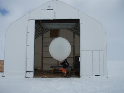
GML Ozonesondes
Summit, Greenland Balloon-Borne Ozonesonde Profile Measurment Program
Location:
Weekly balloon-borne ozone profiles are measured at The Greenland Environmental Observatory (GEOSummit, station code SUM) on the summit of the Greenland Ice Sheet: 72.6° North, 38.5° West: 3202 meters above sea level.
Date of Measurements:February 12, 2005 – current.
You can view vertical profiles of ozone sondes from Summit.
Data files for the Summit ozonesondes can be found at
-
ARCIONS: Arctic Intensive Ozonesonde Network Study
Dates: 2008, April 1-21 & June 25 – July 12 (daily ozonesondes) A North American and Arctic ozonesonde network launched daily ozonesondes in the high-latitudes to look at springtime polar outflow and summertime boreal forest fire impacts on tropospheric ozone budgets. -
MATCH: Determination of Stratospheric Polar Ozone Losse
Dates: 2005-2008 (winter and early spring): The MATCH campaigns are coordinated by the Alfred Wegener Institute for Polar and Marine Research. 20-25 Arctic and high latitude sites launched ozonesondes at specific times during the spring to determine downwind chemical ozone loss in the stratosphere.
The GEOSummit site was established by the U.S. National Science Foundation (NSF) and the Danish Commission for Scientific Research in Greenland to provide year-round, long-term measurements for monitoring and investigations of the Arctic environment.
The facility is operated by CH2M HILL Polar Services (CPS) with guidance from the Science Coordination Office (SCO).

