
More than two years after road access and electrical power to the Mauna Loa Observatory was cut off by lava flows, NOAA staff continue to make critical measurements of the atmosphere and other environmental variables at the remote site.
In 2023, observatory staff installed solar panels at the site and resumed some measurements, including the independent carbon dioxide monitoring programs run by the Global Monitoring Laboratory and Scripps Institution of Oceanography, as well as other atmospheric measurements.
Construction of a temporary road to access the observatory site is anticipated to begin in summer 2025.
Media can contact: Theo Stein (303) 819-7409 (theo.stein@noaa.gov)
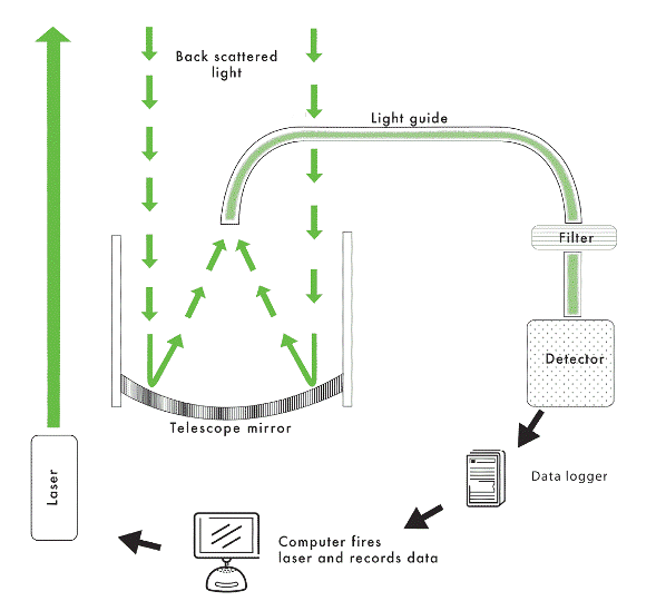
What is Lidar? How Does it Work?
Lidar (LIght Detection And
Ranging), is often refered to as laser radar. Light transmitted by a laser is scattered by atmospheric
consituents and detected by an optical telescope. The properties of the incoming light enable certain properties of the
targets to be determined, and timing of the measurement determines the altitude of the targets.
The NOAA ESRL GMD Lidar Network
The National Oceanic and Atmospheric Administration (NOAA) Earth System Research Laboratory (ESRL), Global Monitoring Laboratory (GMD) operates Lidar at four locations.
- Mauna Loa Observatory, Hawaii (MLO)
- Boulder, Colorado
- Pago Pago, American Samoa (SMO)
- Trinidad Head, California (THD)
At Mauna Loa, Boulder, and Samoa, the Lidars are part of the Network for the Detection of Atmospheric Composition Change (NDACC). At Trinidad Head the Lidar is part of the NASA Micro-pulse lidar network (MPLNET).
What is Camera Lidar? How is it different from Lidar?
CLidar (Camera Lidar), is an innovative on the standard lidar developed at the ESRL Mauna Loa Observatory to measure boundary layer aerosols. Clidar uses a charge-coupled device (CCD) camera to image the entire laser beam from a few hundered meters away.