Measurements at the Mauna Loa Observatory stopped after the 2022 eruption of the Mauna Loa volcano, when lava flow crossed the access road and took out power lines to the facility. The observatory remains inaccessible by vehicle and without power from the local utility company.
Observatory staff has established limited solar power in four observatory buildings and restored approximately 33 percent of the measurements onsite, including the Global Monitoring Laboratory and Scripps critical CO2 records and other atmospheric measurements.
Media can contact: Theo Stein (303) 819-7409 (theo.stein@noaa.gov) or Karin Vergoth 303-632-6413 (karin.vergoth@noaa.gov)
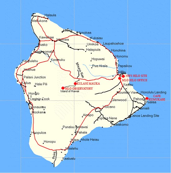
Mauna Loa Observatory (MLO) activities occur at several locations around the Big Island of Hawaii.
- The primary observation site is located at an elevation of 11,141 ft on northern slope of Mauna Loa. This facility is generally refered to as Mauna Loa Observatory, or the MLO Site.
- Behind the scenes, the administration and data processing for MLO occurs at the Hilo Office.
- Kulani Mauka Site is a rain collection site (see National Weather Service programs).
- The Cape Kumukahi Site is a flask sample site located on the eastern most point of Hawaii, used in several programs.
- The Natiaonal Weather Service Hilo Airport Site is where weekly ozonesonde and special water vapor balloons are prepared and launched (see ozonesonde program page).
- The Hakalau Site is a rain collection site for future programs (see EPA Mercury Precipitation program).
- Until January 2006, the MLO main office was located in the historic Federal Building in downtown Hilo
Click on the map to get more information about these sites.


